Finding good snow
For most of us, finding good snow starts with talking. We talk to people with local knowledge. Our similarly-obsessed friends and acquaintances. Local guides. People who spend a lot of time in the mountains.
And there are, of course, keen powder hounds and guides who post on social media about where they’ve been out, with some general information about the conditions. Although the phrase “No friends on powder-days” is, well, true, you can still pick up a lot from your friends (with or without bribes and/or offers to do the driving).
Remember, however, that what you glean fresh off Instagram is so current that local avalanche assessments are your responsibility. Don’t rely on others when it comes to safety and making decisions in avalanche country!
Weather – and avalanche warnings
Always check the avalanche warning at www.varsom.no. And familiarize yourself with the weather report and history before you head out. Avalanche conditions, safety issues and the current state of traffic are mandatory information.
Read ALL of the avalanche advice.
All of it. Not just the headlines. Pay especial attention to:

Read all of the avalanche advice.
https://www.friflyt.no/topptur/de-beste-nettsidene-for-aa-planlegge-topptur
Learn how to read avalanche advice
NVE and varsom.no have made a good explanation of how to read the avalanche warning. Thoroughly familiarise yourself with this (or an equivalent in English). This is basic knowledge to master before setting out touring in potentially avalanche-dangerous terrain.

Weather and geodata – live and historical

Looking for good snow, you’ll want to keep an eye on where the fresh stuff’s been falling. In Norway, the first step is visiting the weather service yr.no. Checking the forecast and the weather for the last few days, especially for the area you’re thinking of visiting, is mandatory.
In the search field, can search yr.no for the name of a place, the name of a peak, or a mountain. You can search for place names at different altitudes, too, to find temperature and wind differences. Careful, though: the more accurate your search, the more accurate the information; it’s not impossible to end up at the wrong place in Norway, where many places share similar names!
Another nice detail at YR.no is that you can look at weather history. Looking at the wind history, for example, you can see if a hurricane’s blown all the snow into the sea. And you can click on “details” in the tab at the top of the search result to get more information about wind direction, precipitation and other useful information.

Xgeo eller seNorge.no are also very useful tools. This is an open portal on the internet showing live maps with snow, weather and climate in Norway. You also have a number of very useful filters like weather stations, steepness maps, ski conditions (yep, really), and an overview of precipitation and snow-depth. This is incredibly practical. Here’s live information: an actual read of the actual weather from actual weather stations. Weather dorks can dork until they drop. With this tool, you are guaranteed to find snow to ski!
At senorge.no, you can, among other things, filter for the depth of new snow and see a forecast for where new snow will fall up to nine (!) days in the future. There’s pleasure in planning.
To really make full use of this tool, pay attention both to where and how the snow’s arriving. Wind direction, tree line, the temperature at altitude, and so on, make for useful information. You can get those details from both YR.no and the weather stations. But here you probably benefit from a little knowledge of geography, topography (terrain), where snow will fall when it’s windy.

If you’re extra clever, then take a look at Regobs, too. Varsom Regobs is an app for Android, iOS and browser giving avalanche warnings from Varsom.no. You can enter observations about snow, risk and avalanches you’ve observed by uploading images and text at a geographical location. A distinction’s made between the information entered by approved avalanche observers and hobby observers like the rest of us. Here you can often find up-to-the-minute information about conditions in the area, perhaps after the avalanche warning has been updated at varsom.no.
Husk at obRemember that the observations can change, and pay attention to the following:
In regObs, observers are ranked according to competence with a number of stars, from none (unknown competence) to five (professional competence). Here’s what the stars mean.
Snow knowledge:
(No stars) – unknown expertise on snow.
* Beginner. The observer knows the basics of assessing avalanche danger. The observer isn’t familiar with how Regobs and Varsom communicate avalanche danger. The competence corresponds to NVE’s level 4ai.
** Experienced observer without qualifications. The observer has experience in assessing avalanche danger. The observer isn’t familiar with how Regobs and Varsom communicate avalanche danger.
*** Qualified observer (basic). The observer has some experience in assessing avalanche danger. The observer has been on a basic course or has equivalent experience in using Regobs and Varsom. Competence corresponds to NVE’s level 4a.
**** Qualified observer (advanced). The observer has much experience in assessing avalanche danger. The observer has been on advanced courses or has equivalent experience in the use of Regobs and Varsom. Competence corresponds to NVE’s level 4b.
* The observer is a member of a notification service. Competence corresponds to NVE’s level 4c.
A – Automated service. Observations come from an automated system. For example, the Swedish road administration has instruments that can detect landslides using sound or radar, reporting landslide activity to Regobs.
Gradiens map and avalanche warning
There are several maps of steep areas – geodata.ngi.no and temakart.nve.no are two. Here you can find safer routes to the top and check if the descent you were thinking of will be too steep. You can also apply a filter for KAST (ATES) terrain classification. Checking varsom.no is required before any ski trip. Read the text warning and understand what it means.

Map tools

Norgeskart offers both a fantastic online service and a good app where you can download sections of a map on to your phone. This is extremely useful if you find yourself out in the wilds with no bars..

HOT TIP
You can usually find place names from Norgeskart in YR.no. It may be useful to know that, as a rule of thumb, 1 mm of precipitation is calculated as approx. 1 cm of snow when it’s cold. And, further, it’s usually calculated that it gets 1° colder for every 100 meters of altitude. This way you can find out, relatively accurately, whether lowland rain will be falling as snow above the tree line..
Crister Næss
Åsnes fixture, ski-guide and outdoor gear nerd
When you want to find good snow, and you’re weighing your options, don’t put all your eggs in one basket. Weather and conditions tend to change quickly – so several plans are just good sense. It’s safer, too – with a Plan A, B, C and D you don’t absolutely HAVE to carry out Plan A if conditions look risky.
With several plans, you can decide the day’s best and safest choice when you set off. With some preparatory work, you don’t have to abandon your trip to the hills if conditions are disappointing. With a good overall plan with decent route descriptions, some skill with a map and compass, and a little advance study of the terrain, you can enjoy yourself is less than ideal weather. This is how you train yourself to navigate in poor visibility!
Wishes, dreams and plans make perfect partners. Online maps are valuable for planning and visualising projects. You can get to know the mountain, the names of streams, ridges, water and landmarks. You can also find alternatives for parking, access roads, tractor paths and alternative routes, getting a head-start on your orientation.
Maps
The official Norwegian map “Norway 1:50,000” can be easily printed for free via the “Mitt turkart” (“My Tur-Map”) tool at norgeskart.no. You can also order maps in larger format from mapsellers.
The maps you print yourself will have almost the same design as the paper maps you buy in the shop, and you can be sure of getting the most recent version. They’re updated weekly. You can also choose exactly which area you want to create a map from. It’s also possible to plan routes, draw on the map, and measure distances.
How to do it
Here’s a demonstration video below to take you through it.

Fatmap is an app that allows 360° views and 3D maps, map layers such as gradient, avalanche ‘release’ zones, and tour planning. Not to mentions a good overview for orientation and topography..
Google Earth and Fatmap are a couple of under-rated tools. Something of a well-kept secret, these tools are frequently used to plan expeditions and find projects beyond the trips that are more generally known.
They allow you to explore satellite images of the entire world and to get a very good 3D view of mountains and terrain with a 360° perspective. You can zoom in and see the mountain from different angles from ground level, letting you get to know the terrain. This is very useful if you’re not familiar, or you’re forming a plan to visit a place without any particular information about route selection. They’re simply very visual, giving a very realistic representation of how things actually look!

Google Earth, also a standalone app, allows you to save your projects and custom views
Norgeskart, and these other map tools, allow you to select a layer of birds-eye images and investigate terrain, even find openings in vegetation. Power lines can, for example, offer great descents when the weather’s untenable in the mountains. You can also measure distances and build altitude profiles.
Tourplanning – safely
Here are a number of articles on tour-planning, safe route choices, and other tips and tricks from the Åsnes Academy brain trust – a lot of extremely useful stuff!

Seven tips for finding a safe route up a mountain
Some simple, concrete, useful tips on how to find safe routes up the mountain. It’s not always easy. But staying safe means good skiing.
FØR DU DRAR PÅ TUR: PLANLEGGING, TOPPTUR

Eight things to check before the season starts!
Before dropping everything and rushing out to ski… keep yourself and your crew safe by ensuring you’re “avalanche ready” before the season gets going!
Trip reports and descriptions of mountains

Peakbook is a portal driven by enthusiasts. A great place for trip reports, descriptions, GPS routes and photos that give a good impression of trips and ascents.
Peakbook and UT.no are an almost inexhaustible source of inspiration, trip descriptions and trip reports. Here you can search for areas or peaks and find a number of good suggestions for tours, with maps, descriptions, gradient profiles and often GPS trails. There’s no reason to reinvent the wheel if someone’s already made a good trip plan!

Hello sunshine

If you’ve ever skied in the spring, you’ll know it’s important to be a little careful in the sun. It’s important to get out early, go up the mountain while the sun’s rising, and descend before sunset. That way you avoid the rock-solid, refrozen snow which makes it difficult to truly let loose.
If you’re planning an ambitious spring project, or you’re concerned about light and sun, then suncalc.net is an excellent stop. Here you can find an overview of when the sun’s at its highest. Start early for optimal light and snow conditions!
Fresh snow pictures

Did you know you can get fresh satellite images of snow conditions in the mountains completely free of charge? Check out https://apps.sentinel-hub.com/sentinel-playground. Move the dates back to early September to see where there was still terrain with snow cover. Because that snow will stay there until next year. It often only takes a few centimetres of new snow in places like this to get good skiing.
Webcams

Kamerakartet.no is an aggregator and overview with links to all publicly available webcams in Norway. Here are live feeds from cameras from services like the Swedish Road Administration, ski resorts and much more. Completely awesome if you want to find out if there really is snow on the mountain, or if word of mouth has puffed up the descriptions a bit!
There’s a great deal a lot of motivation and inspiration to be had watching webcams in the mountains. Check out kamerakartet.no. By monitoring a few chosen cams, you can double check the weather forecast yourself to see whether the snow’s arrived before you jump in the car and head out. Nothing beats seeing 50cm of untouched snow on camera on a Friday. This is the certificate of an excellent weekend.
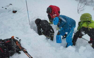
Eight reasons to take a course in avalanche rescue
Avalanche rescue is an essential skill, required by all of us who visit avalanche terrain. No one wants to have to use these skills – but if you ever need them, you need to have them down. True, the most important thing is to avoid being in an avalanche in the first place. But if something were to happen, every second counts. And this means training.

The dog’s mountain code
Norwegian vets say that holiday periods mean more enquiries. The Åsnes Academy has excellent articles on care for your dog in the mountains, including first aid. Here, however, we’ve chosen to put together what we call “the dog’s mountain code” – with some very specific tips for things like the Easter holiday.
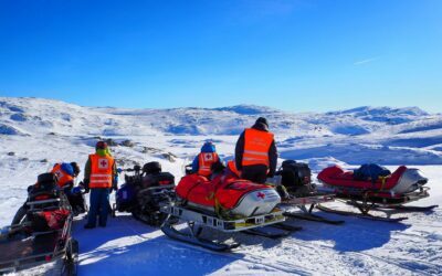
Life-saving first aid in the wilds
A bad fall. A collision. Exposure. Preparation might save a life. As always, it’s a matter of planning and the right packing. With a little knowledge, some practice (and some way to contact the emergency services) you’ll have the basics covered. This could make a life-saving difference.
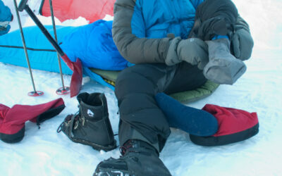
Handling hypothermia
Do you know what to do when you’re faced with someone dangerously cold? Command of the basic facts can be lifesaving – and this is just as relevant for us those of us who hit the mountains for the joy of it as it is for guide and members of the rescue services.
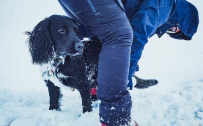
Learn first aid for dogs
Crister Næss, former Åsnes company stalwart, has several years experience as a dog handler in the Norwegian Armed Forces. For him, taking a first aid kit for the dog as is as natural as taking one for other humans.
So – what exactly is a skin, anyway?
Skins are more than a strip of carpet with glue on the back. They’re tools designed to help us in pursuit of pristine snow, perfect lines, and/or solitude. Something this magical demands a proper description of how it’s made.